By Judy Benson
Old Lyme – Despite 300 pages of data, maps and listings of the ecological resources and human uses of Long Island Sound, the inventory created as the foundation for the first-ever marine spatial plan for the estuary isn’t yet complete.
At least that’s the view of two of the speakers at the public hearing May 8 on the draft version of the Long Island Sound Blue Plan Resource and Use Inventory. The hearing took place at the Connecticut Department of Energy and Environmental Protection’s Marine Headquarters.
“You’re missing the activity of the sailors out there,” said Jeff Going, a member of the Essex Harbor Management Commission and board member of the Eastern Connecticut Sailing Association. “These are uses of Long Island Sound that are really important.”
Going urged the committee preparing the inventory, headed by Connecticut Sea Grant Director Sylvain De Guise, to add popular locations for sailing races and yacht club events.
Susan Bryson, a resident of the Short Beach neighborhood in Branford, wanted different information added to the inventory. Beach communities such as hers, she said, should be recognized in the inventory, because “these are the land-based areas that launch a lot of the activities” in the Sound.
“It’s a great gap in your data not to include that,” she said.
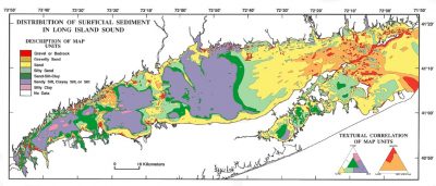
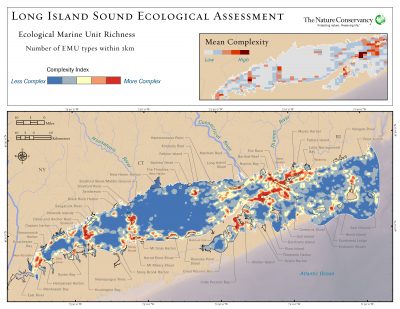
The hearing was the latest step in the two-year–old process of creating the inventory that will be “the basis for what the Blue Plan will become,” said Mary-beth Hart, senior coastal planner for DEEP, which is overseeing creation of the plan. Comments at the hearing and sent to DEEP by May 23 will be incorporated into the final version of the inventory, now comprised of 12 chapters on the Sound’s ecology and 13 chapters on its human uses.
“We’re looking at the different uses and how compatible they are,” Hart said.
At the hearing, De Guise introduced the inventory. Once finalized, he said, it will shape how the Blue Plan is written to “protect the traditional uses of Long Island Sound, minimize conflicts and maximize compatibility, now and in the future.” It will support efforts to preserve the Sound’s ecosystems and resources, and inform “science-based decision making” on future uses and projects in the waterway, he said.
New York State, which has jurisdiction over the southern half of the Sound, is being consulted as the Connecticut Blue Plan is developed, Hart said. The plan will cover areas of the Sound greater than 10 feet deep and as far inland as “up to the first bridge on the rivers,” she added. Other states, including Massachusetts and Rhode Island, have undertaken similar marine spatial planning efforts.
A draft version of the Blue Plan is scheduled to be completed by March 1, 2019. Once that draft is released, another public hearing will take place before the plan is finalized and submitted to the state Legislature for approval.
“We have a lot of work to do in the next eight to nine months,” said Brian Thompson, director of the Land and Water Resources Division at DEEP.
He said the Blue Plan will not impose new regulations on activities in the Sound, but provide a framework for applying existing ones to new uses.
“It does not mean more regulations,” he said. “What it does provide is more tools in the toolbox to help us make decisions based on existing regulations and statutes.”
The draft inventory can be found at: http://www.ct.gov/deep/lisblueplaninventory
Comments on the inventory should be emailed by May 23 to: DEEP.BluePlanLIS@ct.gov.
For information about the Blue Plan, visit: http://www.ct.gov/deep/lisblueplan
Judy Benson is the communications coordinator at Connecticut Sea Grant.